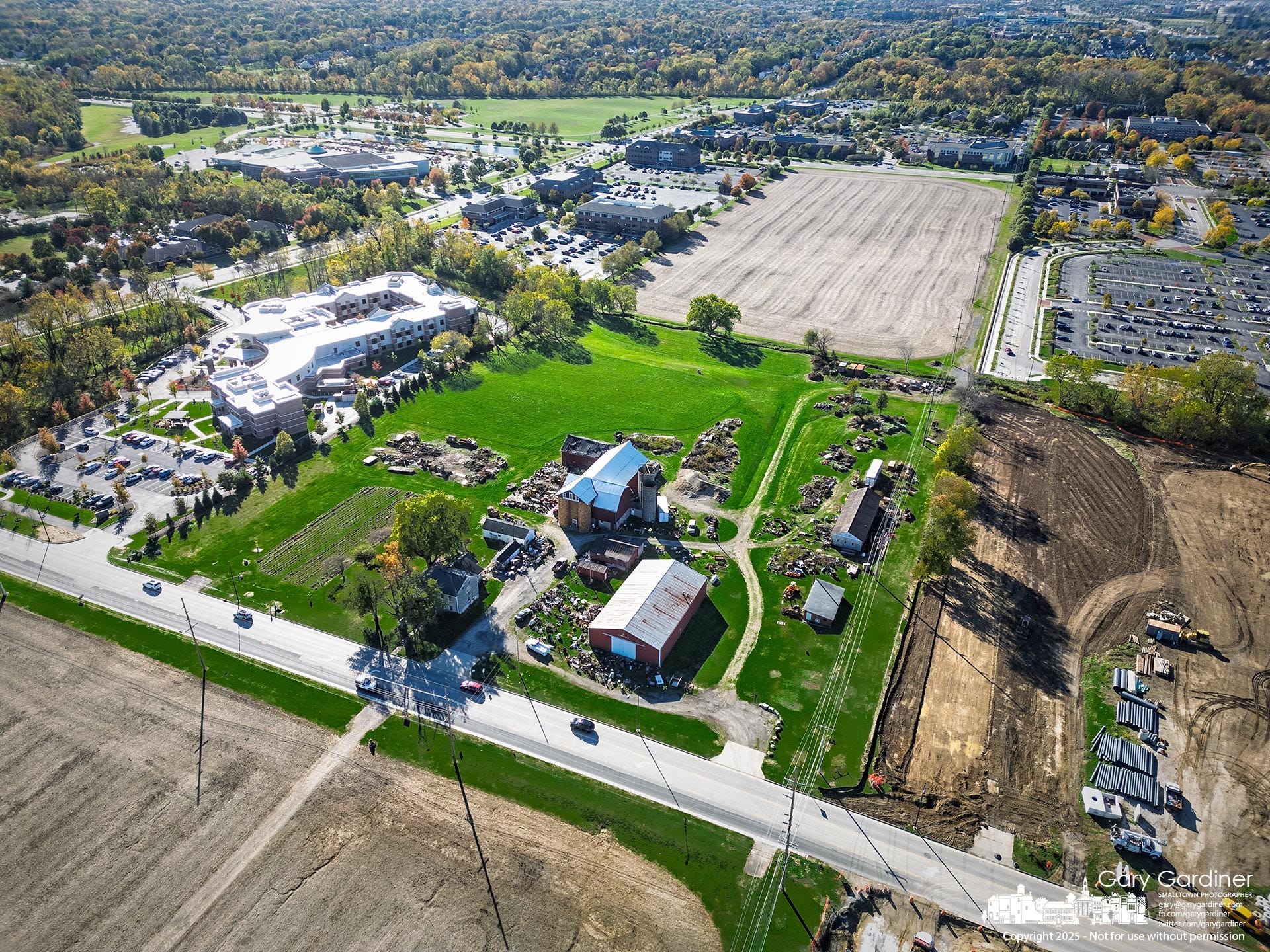
The Yarnell Farm, center, sits immediately south of the East of Africa development site at right. The brown fields in front of and behind the barns are recently harvested soybean plots. The newly graded connector from Westar Boulevard extends along the right edge, awaiting curbs and gutters once the surface dries.
Rain Delays Test Crews Racing to Finish Base Paving Before Asphalt Season Ends
Weather and wet ground slow progress at the East of Africa development, where crews aim to complete all but the top asphalt layer before the plant closes for winter.
A city inspector recently noted that even a single day of rain can delay progress on the project by as much as a week. That estimate makes sense given the current mix of work under way. The crews are building out the storm sewer system, installing underground utility vaults, and preparing new asphalt roads across the 88-acre site. With about half of the curbs, gutters, and base asphalt layers still unfinished, much of the area remains exposed soil and open excavation.
When rain collects in these low sections, crews must wait for the ground to dry before compacting or paving can continue. Standing water softens the subgrade and can ruin newly placed stone or asphalt, forcing rework once the site dries out. Heavy equipment also risks getting stuck or leaving deep ruts that have to be repaired before paving resumes. In effect, what looks like one day lost to weather can add several days of cleanup, re-grading, and testing before work can resume safely.
Recently planted hay fields have begun to sprout, though the shoots are still hard to see from a distance. The hay was planted to preserve the land’s Current Agricultural Use Value (CAUV) tax status while development continues. Additional planting is expected in the coming weeks as work progresses across the remaining sections of the site.
The connecting roadway from Westar Boulevard, west of Africa Road, has already been graded and is ready for curbs and gutters once the rain clears and the surface becomes workable. It will also require a new bridge system over Alkyre Run, the creek that connects to Alum Creek. A section of Alkyre Run between Westar Boulevard and Alum Creek is being prepared for restoration as part of a project to rebuild the wetlands behind the community center.
The new roadway borders the Yarnell Farm, which sits immediately south of the project area. Yarnell remains the largest open green space along Africa Road, framed by recently harvested soybean fields in front of and behind its barns. The surrounding East of Africa farmland has been stripped of grass and trees for grading, leaving Yarnell’s property as one of the last visible reminders of the area’s agricultural past.
At the north end of the project, the three newly formed retention ponds are designed to manage runoff from the future roadways and building sites. The roundabout and adjoining unfinished roadways are just beyond them, still awaiting curbs and final paving. For now, the ponds also serve as a reminder of how much rainfall the site must absorb and manage before work can resume at full pace.
If the weather holds, crews expect to complete all but the finish layer of asphalt on the roads by November. The final paving will wait until spring, as the regional asphalt plant typically closes for the season in mid-November, around Thanksgiving. Once the base paving and curbs are in place, crews will shift attention to final grading, striping, and utility connections that set the stage for the next phase of construction in early 2026.

Dual Fiber Installations Underway Along Africa Road as City Prepares to Remove Utility Poles
Crews on the west side of Africa Road have been installing new fiber optic cables through recently placed conduit as Spectrum upgrades its local network. This project involves a 144-count fiber cable designed to replace the existing overhead lines currently located along the east side of the corridor.
City officials stated that this work is not directly related to the nearby East of Africa development, although the timelines do overlap. The city’s long-term plan to move utilities underground requires service providers to install new conduit before removing the existing poles. Spectrum’s project is intended to ensure uninterrupted service when that transition occurs.
Additionally, a second communications provider has installed its own conduit and fiber within the same trench system. As a result, the area will have a multi-duct corridor containing distinct high-capacity cables, reflecting both growing competition and the city’s shift toward underground utilities.
The fiber optic cable itself is a 144-strand optical bundle that includes twelve color-coded tubes, each containing twelve glass fibers roughly the width of a human hair. Each strand transmits data as modulated light pulses rather than electrical signals, allowing for significantly greater bandwidth and lower signal loss over long distances. In practical terms, a single 144-count cable can support thousands of customer connections through an interconnected system of feeder, distribution, and drop fibers.
Although the project is adjacent to the East of Africa site, officials emphasized that the city mandated this relocation to support utility modernization, not for private development.
Once completed, this corridor will carry electric, cable, and communication lines underground, reducing the risk of outages and preparing the area for future expansion without visible poles or overhead wires.
The Westerville News is a reader-supported publication by Gary Gardiner, a lifelong journalist who believes hyper-local reporting is the future of news. This publication focuses exclusively on Westerville—its local news, influence on Central Ohio, and how surrounding areas shape the community.
Explore more hyper-local reporting by subscribing to The Hilliard Beacon, Civic Capacity, Marysville Matters, The Ohio Roundtable, Shelby News Reporter, This Week in Toledo, and Into the Morning by Krista Steele.
Two traffic signals are planned: one at the new connector to Westar Boulevard, near Yarnell Farm, and the other at the new connection near the Sharp House. These signals will be installed after the project is complete and traffic volume increases on the new roads. The only roundabout in the current plans will be located at the center of the project, where the new road meets the Hoff Road extension.
I am a recent subscriber so you may have already answered this in a previous post. Can you share what roundabouts or traffic signals will be added to Africa Road between Polaris Parkway south to County line Road?