

New Tree Canopy Planned For East of Africa
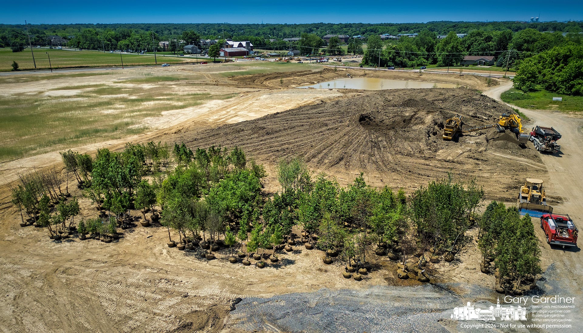
Landscaping began last week at Westerville’s 88-acre East of Africa redevelopment, where about 750 trees are being planted along new roadways, including more than 50 around the historic Sharp House, the project’s best-known landmark and a frequent focus of preservation discussions.
The work offers one of the clearest visible responses yet to residents' complaints about tree clearing at the former farm property, even as the city continues to prepare the site for business development.
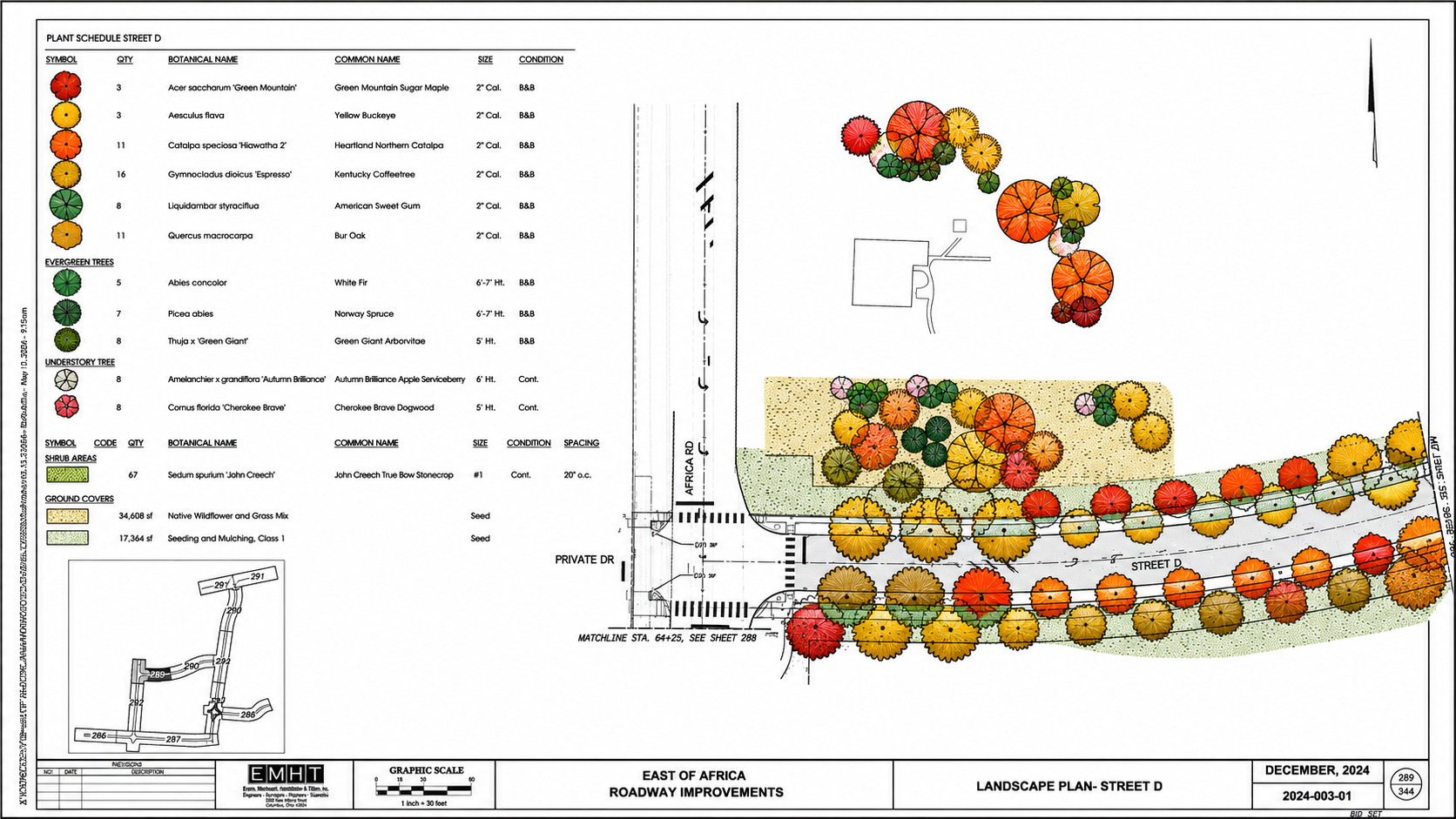
Copies of the city’s landscaping plans for the project show rows of street trees and other plantings along multiple road segments, around key project areas, and near the Sharp House. In an email sent with the plans, Westerville Community Affairs Director Hillary Bates said the first phase calls for about 750 trees and roughly 40 species to create a diverse canopy.
The Sharp House planting plan is dense, but its message is clear: the city intends to surround the project’s best-known landmark with a new canopy. The plan shows more than 50 trees scheduled for planting around the Sharp House and the nearby roadway, compared with five deteriorated black locust trees that were removed during renovation work.
The most prominent feature in the broader landscape plan is along the main boulevard, where the documents show a double row of street trees. City officials said that element grew out of conversations with residents after complaints about the loss of tree cover.
The plans show how public pressure shaped part of the project’s design without changing its broader course. As the city built roads and utility infrastructure to make the property market-ready, it also touched off a dispute over what was being lost: existing trees, farm ground, and a landscape many nearby residents had come to see as part of the neighborhood.
The Sharp House has been a constant focus of discussion throughout the project. The city has hired a team to make needed repairs to the house as redevelopment work nears completion, and the landscaping plans show the landmark as part of the larger East of Africa design rather than a separate preservation effort.
The history of the land is more complicated than a simple clash between trees and development.
In earlier East of Africa presentations, the city included aerial photos from 1959 and 1979 showing much of the property as open pasture where dairy cattle grazed, rather than the wooded landscape many neighbors later associated with the site. Both images also show the dairy barn in the southwest corner of the property, anchoring the site’s farming history in a feature that appears across decades of aerial views.
A 1997 photo shows that same pasture beginning to grow over with trees and shrubs after the city changed the property’s zoning, closing the dairy farm and the farmers’ market on the adjacent Yarnell Farm. By the time the city began preparing the site for development, all 88 acres were still listed as farmland for the agricultural tax benefit.
That farmland use was not just on paper. Open fields on the property grew hay, and fallen trees in the wooded areas were harvested for firewood. In the creek ravine, where the ground was too wet for work vehicles, draft horses were typically used to pull the wood out.
Even now, open areas in the project continue to be farmed. The city has hired a farmer to plant hay on those sections to maintain the agricultural tax status and avoid paying a three-year recoupment charge while it still owns the land. That charge is expected to be passed on to developers as parcels are sold.
The result is a site in transition, still managed in some ways as farm ground even as it is being remade for commercial development.
That layered history helps explain why the tree removals struck such a nerve. For some nearby residents, the issue was not just environmental or aesthetic. It was personal.
A neighboring farmer, who requested anonymity, said one of the older trees removed along the creek bed had the names of family members carved into its trunk. The detail captures how at least part of the site had come to hold both memory and market value.
The city’s response is meant to do more than replace shade. The planting plan ties the new streets, development parcels, and Sharp House area into a single designed landscape intended to soften the site’s transition from farm ground to business-ready land.
The plan calls for a mix of trees expected to provide spring flowers, summer shade, and fall color. Among the selections listed in the documents are dogwoods, serviceberries, lindens, oaks, maples, tupelos, sweet gums, and ginkgoes. Together, those species suggest a landscape designed to be both durable and visually varied across the growing season.
Bates said procurement of the trees is being handled through the project’s infrastructure contract. The contract requires all trees to meet the “American Standard for Nursery Stock,” but the contractor may source trees from any nursery that meets those technical standards and project requirements, she said.
Bates also said the Phase 1 plantings are not the final landscaping planned for the East of Africa site. As individual private sites within the project area are developed, additional plantings will be required and determined through those site-plan approvals.
Even so, the planting plan does not settle the argument that prompted it.
For many residents, the issue was never simply whether the finished development would include landscaping. It was the loss of existing tree cover on land that remained farm ground even as it became part of the area’s everyday landscape.
Newly planted street trees are not the same as mature trees already on the site, and the city’s plans do not explain how the future canopy will compare with what was removed. They also do not settle how many trees were taken down during site preparation, or whether residents will see the new plantings as a meaningful replacement.
That leaves the boulevard and the Sharp House as the clearest public symbols of the city’s response. The double row of trees shows how neighborhood pressure shaped the project, while the plantings around the Sharp House show how the city intends to frame the site’s best-known landmark as redevelopment continues around it.

Because this post is public, you’re encouraged to share it on social media.
The Westerville News is a reader-supported publication by Gary Gardiner, a lifelong journalist who believes hyper-local reporting is the future of news. This publication focuses exclusively on Westerville—its local news, influence on Central Ohio, and how surrounding areas shape the community.
Reader funding, including subscribers, protects editorial independence, so coverage is guided by journalists rather than owners or corporate profit goals. It also reduces pressure to chase clicks, letting the newsroom focus on stories worth readers’ time. And it helps keep the site accessible to everyone, including people who can’t pay or live in places where a free press is under threat.
Explore more hyper-local reporting by subscribing to The Hilliard Beacon, Civic Capacity, Marysville Matters, The Ohio Roundtable, Shelby News Reporter, This Week in Toledo, and Into the Morning by Krista Steele.
